Inbetween The Lines

Since beginning a full-time job in Tokyo I’ve been taking the train to work, and everyday it leaves me with the weirdest feeling of having just passed through the bowels of some otherworldly monster.

Compelled by an unseen force the monster sucks people into its belly where upon it proceeds to first numb them into submission with its orderly queues and then digest them as everyone is squeezed through its suffocating intestines.

The vacant eyes of a hundred strangers staring into space or down at the glowing rectangles in their hands. The silent scream of the woman being squashed between a bunch of sweaty salary men as they use their elbows to force their way into an already-full carriage.


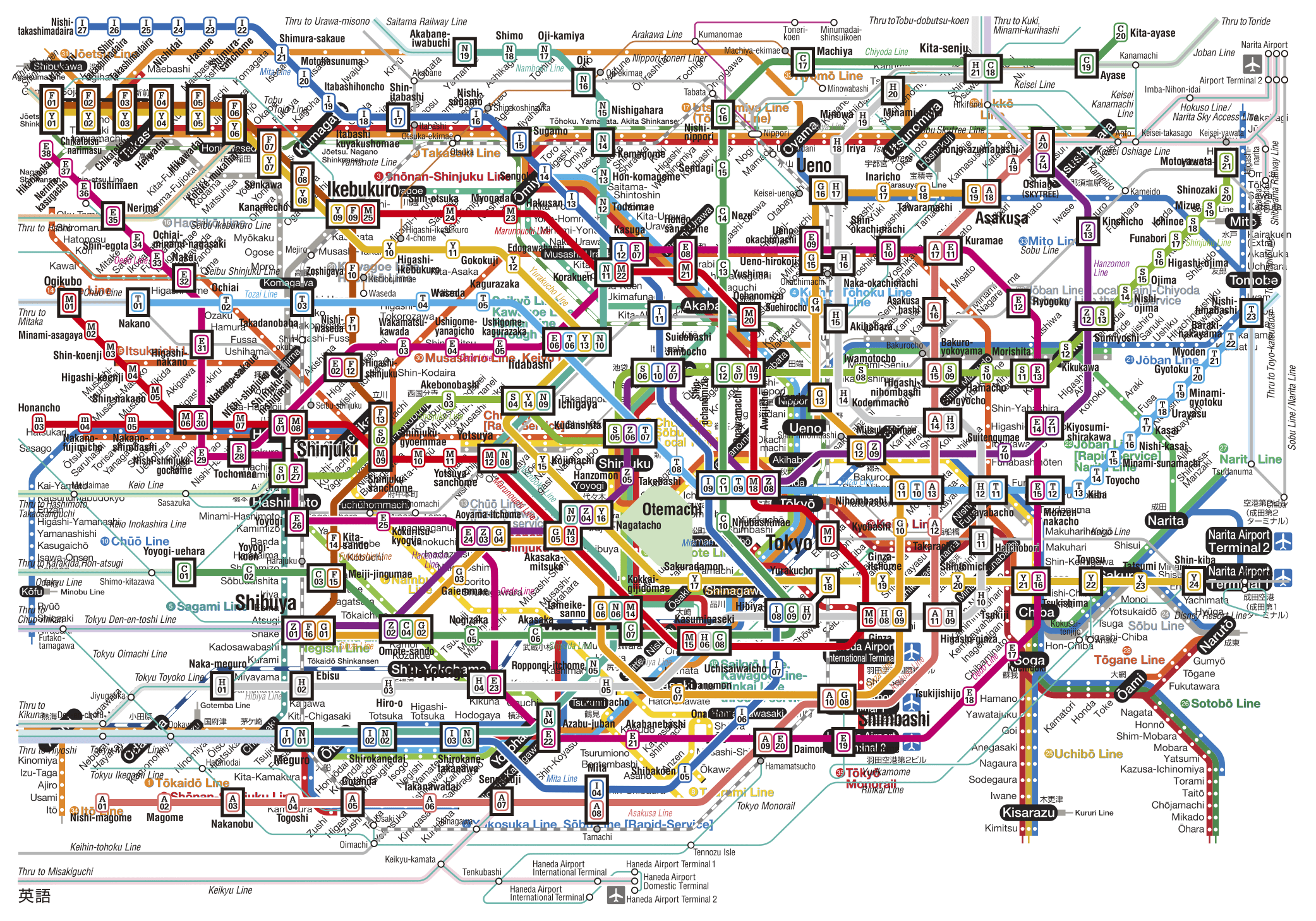
Not a great way to start the day but as far as metropolitan rail networks go Tokyo’s are as pervasive and efficient as they get. With over 130 lines, 1000 stations and 2,000 km of tracks being ridden by 40 million passengers every day it doesn’t get any denser than this (1 station per 1.6 square mile).

What makes things a little complicated is that there are 30 operators, each with their own maps and timetables. The biggest two are JR East (overground) and Tokyo Metro (underground) – without Google Maps it would be a headache to work out the quickest/cheapest route.

JR-Metro Maps Overlayed

For a bit of fun, I decided to try overlaying the JR and Metro maps and above is the result. I think it provides a nice metaphor for the complexity of the system but I sorely wish I had the time to take a crack at designing a real combined map!

David avatar

10 responses

  1. “Since beginning a full-time job in Tokyo”

    Holy crap.

    1. Haha, surprised?

      1. How does one get a full time job in Tokyo these days? What do you do?!

        1. Hey Felix – the answer to how is a bit long and I’ll try to write an article about it soon. As to what, I work for an international tech startup doing product management 🙂

          1. Great! I’m generally interested in working in that part of the world so will look forward to it.

  2. Paul avatar
    Paul

    The real estate agent Sakura House once made a spectacular map of the Tokyo train network that has yet to be surpassed in my humble opinion. Specifically, the one on the rear of their promotional brochure around 2010 was very elegant (after which they inexplicably chose to double-up and stick the Tokyo Metro official map in an inset, cramping the entire masterpiece into an odd L shape). The key to their approach was simple: all underground lines were faintly dotted. Basically, you could then focus your eyes accordingly and easily blur out either the above ground or underground lines. Furthermore, whilst the underground lines often crisscross and were seemingly designed according to immediate need, the above ground lines generally form neat and clean geometric shapes stemming out from the Yamanote loop and Chuo bisector.

  3. Patrick Harnett avatar
    Patrick Harnett

    Those are the two most common maps, but unfortunately they are very different scales. The full combined map available online has not been updated for a long time, but the Suica map is pretty good, even though it misses many of the smaller stops.
    https://www.railplus.com.au/japan-by-rail/suica-card-japan-metro-card/map.htm

    1. Thanks Patrick, I’d never seen that combined map before!

  4. […] ne s’entendent pas forcément entre elles, alors il faut ressortir et repayer. Le tout ça donne ça, c’est illisible ! Je plains les Japonais avant google […]

Reply

Your email address will not be published. Required fields are marked *